How does a Brazilian satellite reach orbit? Science explains.
15 of April, 2026
Share:
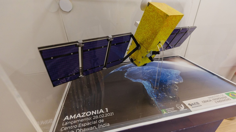
Photo: Luara Baggi (Ascom/MCTI)
Learn about the steps from defining a satellite's mission, through its construction, until it reaches space.
Amazônia-1 (SSR-1) - primeiro satélite de observação da Terra toralmente projetado, integrado, instalado e operado pelo Brasil.
Satellites have transformed our ability to observe, communicate with, and understand the planet. Today, they are essential for weather forecasting, environmental monitoring, navigation, communications, and the production of scientific data, as well as supporting strategic government decisions and economic activities such as agriculture. But what is the process until a satellite enters orbit? Science explains, and reveals: the journey begins long before launch.
In Brazil, the program is coordinated by the Brazilian Space Agency (AEB), and the technical execution is the responsibility of the National Institute for Space Research (Inpe), both linked to the Ministry of Science, Technology and Innovation (MCTI).
In general, projects arise from concrete usage demands. "Whoever is going to use the service of that satellite needs to make very clear what their expectations are regarding performance," explains Rodrigo Leonardi, Director of Portfolio Management at AEB. Furthermore, the project is evaluated by the agency, in conjunction with INPE and MCTI, considering technical feasibility, adherence to the program, and availability of resources.
According to Leonardi, most Brazilian missions begin within the national scientific system itself. "The vast majority of satellites that Brazil has been developing start at a Brazilian ICT [science and technology institute], such as INPE," he explains.
From project to ready satellite
With the satellite ready, the launch phase begins. Currently, Brazil uses international launch vehicles, contracted according to the characteristics of each mission. “And it depends on the intended orbit: whether it's an orbit around the Earth, an orbit we call LEO [low altitude orbit], or a geostationary orbit [high altitude orbit], where it is apparently above a certain region. So, what happens is that for each satellite you have vehicles that enable the intended launch,” explains Rodrigo Leonardi.
In parallel, the country has been advancing in the development of its own space access capabilities, with projects for small-scale launch vehicles, such as the Brazilian Microlauncher (MLBR). In early 2026, a hydrostatic test of the first-stage engine was carried out , with positive results. The objective of this stage is to simulate the main conditions faced during a launch, such as the internal pressure in the engine and the mechanical stresses acting on the vehicle at the moment of takeoff.
The MLBR is made possible through a public call for proposals from the Financing Agency for Studies and Projects (Finep), linked to the Ministry of Science, Technology and Innovation (MCTI), in partnership with the Brazilian Space Agency (AEB), with resources from the National Fund for Scientific and Technological Development (FNDCT), allocated to the Brazilian Space Program (PNAE), and is being developed by a productive arrangement formed by several companies in the technological field. The initiative also has the technical support of the Center for Management and Strategic Studies (CGEE) and the support of the Brazilian Aerospace Industries Association (AIAB).
Furthermore, the country is committed to expanding the infrastructure of the Alcântara Launch Center in Maranhão (MA), which is being prepared for national and international operations. Located approximately 2 degrees from the Equator, the center offers technical conditions considered ideal for space operations, such as fuel economy, favoring more efficient launches for certain orbital insertions, advantageous geographical and operational conditions, and infrastructure dedicated to the preparation, integration, and launch of space vehicles.
After the launch is scheduled, the satellite is transported to the base. "It has to be transported to the launch site by plane, carefully secured," explains the head of the Postgraduate Division at INPE, Antônio Bertachini. At the site, it is integrated into the rocket in a structure designed to withstand intense vibrations during takeoff.
The launch is the most critical stage. "The rocket provides initial speed, takes the satellite to the height it needs to be at the moment of injection into orbit, and then it is separated from the rocket," explains the researcher. From that moment on, the satellite remains orbiting the Earth due to the balance between the forces caused by rotation and gravity. "Considering a simplified model, where only Earth's gravity acts and the planet is treated as perfectly spherical, the satellite remains orbiting the Earth the entire time, but it doesn't fall," he summarizes.
How does this balance work?
Objects remain in Earth's orbit thanks to the "push" given by the launch rocket. The injection into orbit, mentioned by Bertachini, happens during the propulsion stage, when the satellite is launched at over 28,000 km/h. The speed is high enough so that it doesn't fall to Earth, but also doesn't escape the planet's gravity.
“Think of it this way: if you throw a stone, it falls a certain distance. If you throw it with more force, it goes further. Now, if you could give it a very high speed, on the order of 11 kilometers per second, it would move forward and begin to fall following the curvature of the Earth,” explains Antônio Bertachini. “So, it is always falling, but since the Earth is spherical, at the moment it is about to fall, the surface 'ends,' and it continues to rotate.”
In practice, this means that the satellite is in constant freefall around the planet. It doesn't remain stationary in space: it is always being pulled by gravity, but at a speed sufficient to continue "falling around" the Earth without hitting the surface. However, not all satellites behave the same way in orbit. Some continuously travel to different regions of the planet, such as Earth observation satellites. Others, such as telecommunications satellites, operate in geostationary orbit, at an altitude of about 36,000 kilometers, following the Earth's rotation and remaining fixed for an observer on the planet.
There are also situations where this balance is not permanent. In lower orbits, for example, there is still a small interaction with the atmosphere, which reduces the satellite's speed over time. "If it is in a low orbit, it comes into contact with the atmosphere and loses energy. Then it starts to fall faster and may re-enter," explains Bertachini.
That's why many satellites have propulsion systems. These small engines allow them to correct their trajectory, maintain altitude, and even change position when necessary. "To avoid falling, you need to perform maneuvers. You activate the thruster and gradually raise its orbit," he says.
Orbital operation and risks
After being placed in orbit, the satellite is continuously monitored. INPE operates the system from antennas on the ground and from the Satellite Tracking and Control Center (CRC) in São José dos Campos (SP). "The satellites pass by the antennas, send signals, and we receive this information to calculate the orbit and predict where it will pass," explains Bertachini.
This stage also involves significant challenges. One of the main ones is in the launch itself. "For it to reach the correct orbit, it's primarily the launcher's job," he says. Failures can compromise the entire mission: "If it burns irregularly or has the wrong propulsion direction, the satellite will not reach the desired orbit."
Already in operation, another growing risk is collision with space debris. "From time to time, a collision risk warning comes, and you need to execute a maneuver to avoid it," he explains.
Throughout the mission, the satellite collects information that is transmitted to Earth and processed by specialized teams. "The data is captured by the stations and transferred to the control center, which then passes it on to the responsible teams," says Bertachini. From there, each group processes this material according to its application—whether it's environmental monitoring, meteorological data, or scientific research.
This entire process takes time. "It's a very complex and, most of the time, lengthy cycle," explains Leonardi. On average, according to Bertachini, complete projects take "at least two to three years," and can be faster for smaller satellites.
From space to society
These systems are responsible for providing strategic data for public policies and land management, consolidating an area in which Brazil already has a tradition and technological expertise. The images and information generated by these satellites feed environmental monitoring agencies and help guide enforcement actions, planning, and response to extreme events.
For the coming years, the trend is to expand this capacity. "The short- and medium-term priority is the production of Earth observation and telecommunications satellites," explains Leonardi. According to him, the continuation of this strategy is already underway, with new projects in development, such as Amazônia-1B, which should continue the environmental monitoring mission with technological improvements.
Source: Ministry of Science, Technology and Innovation (MCTI).
Related news
The 5th "Space in Focus" webinar addresses satellite navigation (PNT) and national sovereignty.
4 of May, 2026The webinar featured the participation of experts and promoted discussion on strengthening national capabilities in National Technology and its impacts on areas such as defense, infrastructure, logistics, and innovation.
CGEE participates in GSI webinar on challenges of the National Transportation Plan in Brazil.
23 of April, 2026The webinar will feature expert participation and promote discussion on strengthening national capabilities in National Technology Planning (NTP) and its impacts on areas such as defense, infrastructure, logistics, and innovation.
Brazilian micro-launcher successfully passes motor endurance test.
24 of February, 2026Testing conducted by MLBR confirmed the system's robustness and exceeded the pressures predicted for operation.